


La hulpe 25kms

CapTom
User
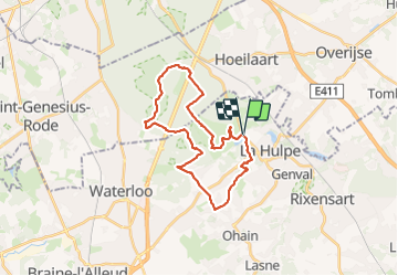

Length
25 km

Max alt
152 m

Uphill gradient
382 m
Km-Effort
30 km

Min alt
63 m

Downhill gradient
376 m
Boucle
Yes
Creation date :
2023-07-17 07:43:53.0
Updated on :
2023-07-17 15:57:47.56
5h01
Difficulty : Easy

FREE GPS app for hiking
 SityTrail
IGN / Geographical institutes
SityTrail Plus
The world is yours!
About
Trail Walking of 25 km to be discovered at Wallonia, Walloon Brabant, La Hulpe. This trail is proposed by CapTom.
Positioning
Country:
Belgium
Region :
Wallonia
Department/Province :
Walloon Brabant
Municipality :
La Hulpe
Location:
Unknown
Start:(Dec)
Start:(UTM)
603924 ; 5621637 (31U) N.
Comments