


Randonnée Bucey 18 07 2023

FPortier
User
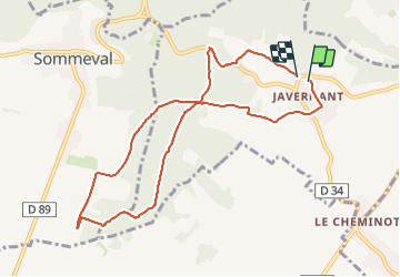

Length
9 km

Max alt
306 m

Uphill gradient
234 m
Km-Effort
12.1 km

Min alt
190 m

Downhill gradient
232 m
Boucle
Yes
Creation date :
2023-07-18 07:03:37.548
Updated on :
2023-07-18 09:40:34.543
2h36
Difficulty : Difficult

FREE GPS app for hiking
 SityTrail
IGN / Geographical institutes
SityTrail Plus
The world is yours!
About
Trail Walking of 9 km to be discovered at Grand Est, Aube, Javernant. This trail is proposed by FPortier.
Description
Bucey 18/07/2023
Positioning
Country:
France
Region :
Grand Est
Department/Province :
Aube
Municipality :
Javernant
Location:
Unknown
Start:(Dec)
Start:(UTM)
574560 ; 5334790 (31U) N.
Comments