


rea1807

JPS73
User
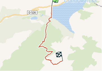

Length
5.5 km

Max alt
2487 m

Uphill gradient
828 m
Km-Effort
13.9 km

Min alt
1678 m

Downhill gradient
50 m
Boucle
No
Creation date :
2023-07-18 07:09:33.047
Updated on :
2023-07-18 10:36:12.615
2h08
Difficulty : Difficult

FREE GPS app for hiking
 SityTrail
IGN / Geographical institutes
SityTrail Plus
The world is yours!
About
Trail Walking of 5.5 km to be discovered at Auvergne-Rhône-Alpes, Isère, Vaujany. This trail is proposed by JPS73.
Positioning
Country:
France
Region :
Auvergne-Rhône-Alpes
Department/Province :
Isère
Municipality :
Vaujany
Location:
Unknown
Start:(Dec)
Start:(UTM)
273607 ; 5010132 (32T) N.
Comments