


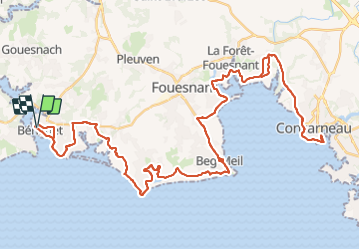
Benodet Concarneau

duchaine.nicolas
User

Length
77 km

Max alt
65 m

Uphill gradient
681 m
Km-Effort
86 km

Min alt
-1 m

Downhill gradient
682 m
Boucle
Yes
Creation date :
2023-07-19 09:02:24.497
Updated on :
2023-07-19 15:49:20.634
--
Difficulty : Very difficult

FREE GPS app for hiking
 SityTrail
IGN / Geographical institutes
SityTrail Plus
The world is yours!
About
Trail Bicycle tourism of 77 km to be discovered at Brittany, Finistère, Bénodet. This trail is proposed by duchaine.nicolas.
Description
Via une portion de la voie verte n° 5 (et quelques petites variantes 😉)
Positioning
Country:
France
Region :
Brittany
Department/Province :
Finistère
Municipality :
Bénodet
Location:
Unknown
Start:(Dec)
Start:(UTM)
416816 ; 5303117 (30T) N.
Comments