


Chemin des cigales Granges les Beaumont

meillon
User

Length
3.4 km

Max alt
138 m

Uphill gradient
14 m
Km-Effort
3.5 km

Min alt
130 m

Downhill gradient
11 m
Boucle
Yes
Creation date :
2023-07-19 18:02:38.784
Updated on :
2023-07-19 19:51:59.049
1h48
Difficulty : Easy

FREE GPS app for hiking
 SityTrail
IGN / Geographical institutes
SityTrail Plus
The world is yours!
About
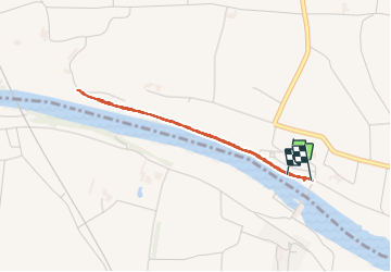
Trail Walking of 3.4 km to be discovered at Auvergne-Rhône-Alpes, Drôme, Granges-les-Beaumont. This trail is proposed by meillon.
Description
suivre l isere et revenir vers le barrage de la vanesle
Positioning
Country:
France
Region :
Auvergne-Rhône-Alpes
Department/Province :
Drôme
Municipality :
Granges-les-Beaumont
Location:
Unknown
Start:(Dec)
Start:(UTM)
656188 ; 4989022 (31T) N.
Comments