


25_km_vers_gerardmer-15935125-1689802089-125

Sefi78
User
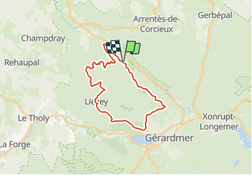

Length
25 km

Max alt
946 m

Uphill gradient
916 m
Km-Effort
37 km

Min alt
581 m

Downhill gradient
918 m
Boucle
Yes
Creation date :
2023-07-19 21:33:54.878
Updated on :
2023-07-19 21:35:59.204
--
Difficulty : Easy

FREE GPS app for hiking
 SityTrail
IGN / Geographical institutes
SityTrail Plus
The world is yours!
About
Trail Equestrian of 25 km to be discovered at Grand Est, Vosges, Granges-Aumontzey. This trail is proposed by Sefi78.
Positioning
Country:
France
Region :
Grand Est
Department/Province :
Vosges
Municipality :
Granges-Aumontzey
Location:
Granges-sur-Vologne
Start:(Dec)
Start:(UTM)
338734 ; 5331861 (32U) N.
Comments