


15_km_le_neu_pres-15892639-1689802053-300

Sefi78
User
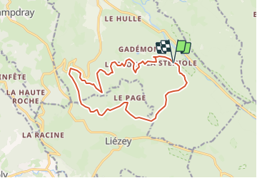

Length
14.9 km

Max alt
884 m

Uphill gradient
497 m
Km-Effort
22 km

Min alt
629 m

Downhill gradient
499 m
Boucle
Yes
Creation date :
2023-07-19 21:33:55.806
Updated on :
2023-07-19 21:38:23.363
--
Difficulty : Very easy

FREE GPS app for hiking
 SityTrail
IGN / Geographical institutes
SityTrail Plus
The world is yours!
About
Trail Equestrian of 14.9 km to be discovered at Grand Est, Vosges, Granges-Aumontzey. This trail is proposed by Sefi78.
Positioning
Country:
France
Region :
Grand Est
Department/Province :
Vosges
Municipality :
Granges-Aumontzey
Location:
Granges-sur-Vologne
Start:(Dec)
Start:(UTM)
338719 ; 5331868 (32U) N.
Comments