


Sentier des Crans_2023

nathycandy
User
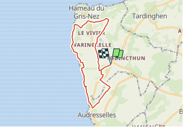

Length
13 km

Max alt
68 m

Uphill gradient
156 m
Km-Effort
15.1 km

Min alt
8 m

Downhill gradient
156 m
Boucle
Yes
Creation date :
2023-07-20 06:45:12.818
Updated on :
2023-07-20 06:46:12.775
3h25
Difficulty : Difficult

FREE GPS app for hiking
 SityTrail
IGN / Geographical institutes
SityTrail Plus
The world is yours!
About
Trail Walking of 13 km to be discovered at Hauts-de-France, Pas-de-Calais, Audinghen. This trail is proposed by nathycandy.
Positioning
Country:
France
Region :
Hauts-de-France
Department/Province :
Pas-de-Calais
Municipality :
Audinghen
Location:
Unknown
Start:(Dec)
Start:(UTM)
401816 ; 5633579 (31U) N.
Comments