Trail Horseback riding Thoard - 2023-09-30 Rando CVA Monges Thoard vers St Geniez - Photo

2023-09-30 Rando CVA Monges Thoard vers St Geniez

 holtzv
holtzv

User GUIDE

© OpenStreetMap contributors
Length
Length
27 km
Max alt
Max alt
1433 m
Uphill gradient
Uphill gradient
1322 m
Km-Effort
Km-Effort  
45 km
Min alt
Min alt
710 m
Downhill gradient
Downhill gradient
1156 m
Boucle
Boucle
No
Creation date :
2023-07-20 12:35:06.757
Updated on :
2023-10-10 07:56:10.255

(0 Reviews)

Horseback riding
Horseback riding
5h51
Difficulty : Very difficult

Scan this QR Code to open this trail in the SityTrail application

FREE GPS app for hiking

Logo SityTrail SityTrail

IGN / Geographical institutes

Download SityTrail from the App Store Download SityTrail from Google Play

Logo SityTrail SityTrail Plus

The world is yours!

Download SityTrail from the App Store Download SityTrail from Google Play Download SityTrail on Huawei AppGallery

About

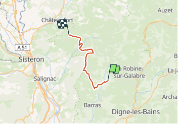
Trail Horseback riding of 27 km to be discovered at Provence-Alpes-Côte d'Azur, Alpes-de-Haute-Provence, Thoard. This trail is proposed by holtzv.

Description

Thoard - Saint-Geniez (5h)
Gîtes à Thoard et Saint-Geniez
Au départ du village de Thoard, gravir la montagne de Vaumuse par le sentier équestre, pour suivre les crêtes jusqu’au sommet et par le GR©406 arriver au col de Mounis (vue époustouflante).
De là vous rejoignez la vallée du Vançon, sauvage et mystérieuse, par le GR®6.
Le vieux chemin d’Abros (balisé jaune) vous ramène vers le Rocher de Dromont et le hameau de Chabert.

Elevation profile

Positioning

Country:
France
Region :
Provence-Alpes-Côte d'Azur
Department/Province :
Alpes-de-Haute-Provence
Municipality :
Thoard
Location:
Unknown
Start:(UTM)
272760 ; 4892936 (32T) N.


Close
My subscriptions