


Lac Bénit

Chabard
User
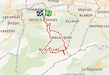

Length
15.2 km

Max alt
1741 m

Uphill gradient
990 m
Km-Effort
28 km

Min alt
959 m

Downhill gradient
991 m
Boucle
Yes
Creation date :
2023-07-20 07:19:24.0
Updated on :
2023-07-20 14:05:32.58
6h45
Difficulty : Difficult

FREE GPS app for hiking
 SityTrail
IGN / Geographical institutes
SityTrail Plus
The world is yours!
About
Trail Walking of 15.2 km to be discovered at Auvergne-Rhône-Alpes, Upper Savoy, Mont-Saxonnex. This trail is proposed by Chabard.
Description
Par Mont Saxonnex
Positioning
Country:
France
Region :
Auvergne-Rhône-Alpes
Department/Province :
Upper Savoy
Municipality :
Mont-Saxonnex
Location:
Unknown
Start:(Dec)
Start:(UTM)
305097 ; 5102743 (32T) N.
Comments