


Aulus

Evelyne Bouchereau
User
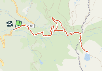

Length
7.1 km

Max alt
1893 m

Uphill gradient
497 m
Km-Effort
13.7 km

Min alt
1386 m

Downhill gradient
500 m
Boucle
Yes
Creation date :
2023-07-20 09:53:53.553
Updated on :
2023-07-20 14:11:14.853
2h18
Difficulty : Difficult

FREE GPS app for hiking
 SityTrail
IGN / Geographical institutes
SityTrail Plus
The world is yours!
About
Trail Walking of 7.1 km to be discovered at Occitania, Ariège, Aulus-les-Bains. This trail is proposed by Evelyne Bouchereau.
Positioning
Country:
France
Region :
Occitania
Department/Province :
Ariège
Municipality :
Aulus-les-Bains
Location:
Unknown
Start:(Dec)
Start:(UTM)
367829 ; 4737894 (31T) N.
Comments