


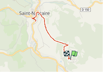
DU CAMPING " LE VIGINET " A SAINT-NECTAIRE

walrou63
User

Length
4.4 km

Max alt
775 m

Uphill gradient
137 m
Km-Effort
6.2 km

Min alt
703 m

Downhill gradient
137 m
Boucle
Yes
Creation date :
2023-07-21 13:15:21.475
Updated on :
2023-07-22 09:26:03.345
1h15
Difficulty : Medium

FREE GPS app for hiking
 SityTrail
IGN / Geographical institutes
SityTrail Plus
The world is yours!
About
Trail Walking of 4.4 km to be discovered at Auvergne-Rhône-Alpes, Puy-de-Dôme, Saint-Nectaire. This trail is proposed by walrou63.
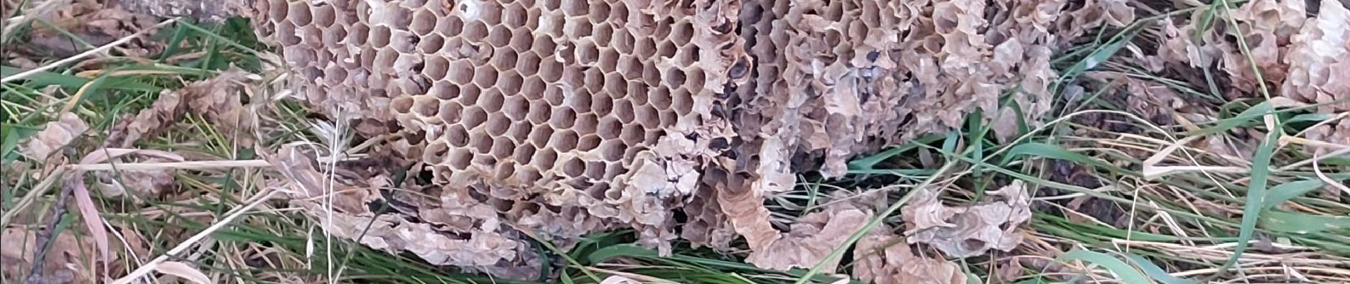
Photos
"
data-pinterest-text="Pin it"
data-tweet-text="share on twitter"
data-facebook-share-url="https://www.sitytrail.com/en/trails/3742467-saintxnectaire--du-camping-x-le-viginet-x-a-saintxnectaire/?photo=0#lg=1&slide=0"
data-twitter-share-url="https://www.sitytrail.com/en/trails/3742467-saintxnectaire--du-camping-x-le-viginet-x-a-saintxnectaire/?photo=0#lg=1&slide=0"
data-googleplus-share-url="https://www.sitytrail.com/en/trails/3742467-saintxnectaire--du-camping-x-le-viginet-x-a-saintxnectaire/?photo=0#lg=1&slide=0"
data-pinterest-share-url="https://www.sitytrail.com/en/trails/3742467-saintxnectaire--du-camping-x-le-viginet-x-a-saintxnectaire/?photo=0#lg=1&slide=0">
 "
data-pinterest-text="Pin it"
data-tweet-text="share on twitter"
data-facebook-share-url="https://www.sitytrail.com/en/trails/3742467-saintxnectaire--du-camping-x-le-viginet-x-a-saintxnectaire/?photo=1#lg=1&slide=1"
data-twitter-share-url="https://www.sitytrail.com/en/trails/3742467-saintxnectaire--du-camping-x-le-viginet-x-a-saintxnectaire/?photo=1#lg=1&slide=1"
data-googleplus-share-url="https://www.sitytrail.com/en/trails/3742467-saintxnectaire--du-camping-x-le-viginet-x-a-saintxnectaire/?photo=1#lg=1&slide=1"
data-pinterest-share-url="https://www.sitytrail.com/en/trails/3742467-saintxnectaire--du-camping-x-le-viginet-x-a-saintxnectaire/?photo=1#lg=1&slide=1">
"
data-pinterest-text="Pin it"
data-tweet-text="share on twitter"
data-facebook-share-url="https://www.sitytrail.com/en/trails/3742467-saintxnectaire--du-camping-x-le-viginet-x-a-saintxnectaire/?photo=1#lg=1&slide=1"
data-twitter-share-url="https://www.sitytrail.com/en/trails/3742467-saintxnectaire--du-camping-x-le-viginet-x-a-saintxnectaire/?photo=1#lg=1&slide=1"
data-googleplus-share-url="https://www.sitytrail.com/en/trails/3742467-saintxnectaire--du-camping-x-le-viginet-x-a-saintxnectaire/?photo=1#lg=1&slide=1"
data-pinterest-share-url="https://www.sitytrail.com/en/trails/3742467-saintxnectaire--du-camping-x-le-viginet-x-a-saintxnectaire/?photo=1#lg=1&slide=1">
 "
data-pinterest-text="Pin it"
data-tweet-text="share on twitter"
data-facebook-share-url="https://www.sitytrail.com/en/trails/3742467-saintxnectaire--du-camping-x-le-viginet-x-a-saintxnectaire/?photo=2#lg=1&slide=2"
data-twitter-share-url="https://www.sitytrail.com/en/trails/3742467-saintxnectaire--du-camping-x-le-viginet-x-a-saintxnectaire/?photo=2#lg=1&slide=2"
data-googleplus-share-url="https://www.sitytrail.com/en/trails/3742467-saintxnectaire--du-camping-x-le-viginet-x-a-saintxnectaire/?photo=2#lg=1&slide=2"
data-pinterest-share-url="https://www.sitytrail.com/en/trails/3742467-saintxnectaire--du-camping-x-le-viginet-x-a-saintxnectaire/?photo=2#lg=1&slide=2">
"
data-pinterest-text="Pin it"
data-tweet-text="share on twitter"
data-facebook-share-url="https://www.sitytrail.com/en/trails/3742467-saintxnectaire--du-camping-x-le-viginet-x-a-saintxnectaire/?photo=2#lg=1&slide=2"
data-twitter-share-url="https://www.sitytrail.com/en/trails/3742467-saintxnectaire--du-camping-x-le-viginet-x-a-saintxnectaire/?photo=2#lg=1&slide=2"
data-googleplus-share-url="https://www.sitytrail.com/en/trails/3742467-saintxnectaire--du-camping-x-le-viginet-x-a-saintxnectaire/?photo=2#lg=1&slide=2"
data-pinterest-share-url="https://www.sitytrail.com/en/trails/3742467-saintxnectaire--du-camping-x-le-viginet-x-a-saintxnectaire/?photo=2#lg=1&slide=2">

 "
data-pinterest-text="Pin it"
data-tweet-text="share on twitter"
data-facebook-share-url="https://www.sitytrail.com/en/trails/3742467-saintxnectaire--du-camping-x-le-viginet-x-a-saintxnectaire/?photo=1#lg=1&slide=1"
data-twitter-share-url="https://www.sitytrail.com/en/trails/3742467-saintxnectaire--du-camping-x-le-viginet-x-a-saintxnectaire/?photo=1#lg=1&slide=1"
data-googleplus-share-url="https://www.sitytrail.com/en/trails/3742467-saintxnectaire--du-camping-x-le-viginet-x-a-saintxnectaire/?photo=1#lg=1&slide=1"
data-pinterest-share-url="https://www.sitytrail.com/en/trails/3742467-saintxnectaire--du-camping-x-le-viginet-x-a-saintxnectaire/?photo=1#lg=1&slide=1">
"
data-pinterest-text="Pin it"
data-tweet-text="share on twitter"
data-facebook-share-url="https://www.sitytrail.com/en/trails/3742467-saintxnectaire--du-camping-x-le-viginet-x-a-saintxnectaire/?photo=1#lg=1&slide=1"
data-twitter-share-url="https://www.sitytrail.com/en/trails/3742467-saintxnectaire--du-camping-x-le-viginet-x-a-saintxnectaire/?photo=1#lg=1&slide=1"
data-googleplus-share-url="https://www.sitytrail.com/en/trails/3742467-saintxnectaire--du-camping-x-le-viginet-x-a-saintxnectaire/?photo=1#lg=1&slide=1"
data-pinterest-share-url="https://www.sitytrail.com/en/trails/3742467-saintxnectaire--du-camping-x-le-viginet-x-a-saintxnectaire/?photo=1#lg=1&slide=1">
 "
data-pinterest-text="Pin it"
data-tweet-text="share on twitter"
data-facebook-share-url="https://www.sitytrail.com/en/trails/3742467-saintxnectaire--du-camping-x-le-viginet-x-a-saintxnectaire/?photo=2#lg=1&slide=2"
data-twitter-share-url="https://www.sitytrail.com/en/trails/3742467-saintxnectaire--du-camping-x-le-viginet-x-a-saintxnectaire/?photo=2#lg=1&slide=2"
data-googleplus-share-url="https://www.sitytrail.com/en/trails/3742467-saintxnectaire--du-camping-x-le-viginet-x-a-saintxnectaire/?photo=2#lg=1&slide=2"
data-pinterest-share-url="https://www.sitytrail.com/en/trails/3742467-saintxnectaire--du-camping-x-le-viginet-x-a-saintxnectaire/?photo=2#lg=1&slide=2">
"
data-pinterest-text="Pin it"
data-tweet-text="share on twitter"
data-facebook-share-url="https://www.sitytrail.com/en/trails/3742467-saintxnectaire--du-camping-x-le-viginet-x-a-saintxnectaire/?photo=2#lg=1&slide=2"
data-twitter-share-url="https://www.sitytrail.com/en/trails/3742467-saintxnectaire--du-camping-x-le-viginet-x-a-saintxnectaire/?photo=2#lg=1&slide=2"
data-googleplus-share-url="https://www.sitytrail.com/en/trails/3742467-saintxnectaire--du-camping-x-le-viginet-x-a-saintxnectaire/?photo=2#lg=1&slide=2"
data-pinterest-share-url="https://www.sitytrail.com/en/trails/3742467-saintxnectaire--du-camping-x-le-viginet-x-a-saintxnectaire/?photo=2#lg=1&slide=2">

Positioning
Country:
France
Region :
Auvergne-Rhône-Alpes
Department/Province :
Puy-de-Dôme
Municipality :
Saint-Nectaire
Location:
Unknown
Start:(Dec)
Start:(UTM)
500260 ; 5047247 (31T) N.
Comments