


esparros pacte des l 2023

LouisROGER
User GUIDE
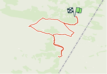

Length
10.7 km

Max alt
1262 m

Uphill gradient
507 m
Km-Effort
17.5 km

Min alt
813 m

Downhill gradient
507 m
Boucle
Yes
Creation date :
2023-07-21 07:47:02.477
Updated on :
2023-07-21 17:39:44.492
4h41
Difficulty : Difficult

FREE GPS app for hiking
 SityTrail
IGN / Geographical institutes
SityTrail Plus
The world is yours!
About
Trail Walking of 10.7 km to be discovered at Occitania, Hautespyrenees, Esparros. This trail is proposed by LouisROGER.
Photos


Positioning
Country:
France
Region :
Occitania
Department/Province :
Hautespyrenees
Municipality :
Esparros
Location:
Unknown
Start:(Dec)
Start:(UTM)
282044 ; 4765229 (31T) N.
Comments