


Estenc rando 1

Christiancordin
User
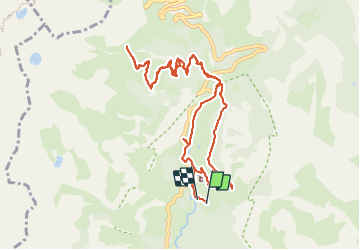

Length
13 km

Max alt
2315 m

Uphill gradient
627 m
Km-Effort
21 km

Min alt
1693 m

Downhill gradient
623 m
Boucle
Yes
Creation date :
2023-06-05 09:40:27.584
Updated on :
2023-07-23 13:10:45.696
3h32
Difficulty : Medium

FREE GPS app for hiking
 SityTrail
IGN / Geographical institutes
SityTrail Plus
The world is yours!
About
Trail Walking of 13 km to be discovered at Provence-Alpes-Côte d'Azur, Maritime Alps, Entraunes. This trail is proposed by Christiancordin.
Description
Estenc
Photos


Positioning
Country:
France
Region :
Provence-Alpes-Côte d'Azur
Department/Province :
Maritime Alps
Municipality :
Entraunes
Location:
Unknown
Start:(Dec)
Start:(UTM)
320741 ; 4899926 (32T) N.
Comments