


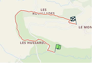
Chastreix Cascade

Papou63patrick
User

Length
1.9 km

Max alt
1094 m

Uphill gradient
76 m
Km-Effort
2.7 km

Min alt
1030 m

Downhill gradient
33 m
Boucle
No
Creation date :
2023-07-23 13:27:18.806
Updated on :
2023-07-23 14:16:16.776
31m
Difficulty : Medium

FREE GPS app for hiking
 SityTrail
IGN / Geographical institutes
SityTrail Plus
The world is yours!
About
Trail Walking of 1.9 km to be discovered at Auvergne-Rhône-Alpes, Puy-de-Dôme, Chastreix. This trail is proposed by Papou63patrick.
Positioning
Country:
France
Region :
Auvergne-Rhône-Alpes
Department/Province :
Puy-de-Dôme
Municipality :
Chastreix
Location:
Unknown
Start:(Dec)
Start:(UTM)
479899 ; 5039009 (31T) N.
Comments