


VENANSON - LIBARET -CONDAMINES

Benteux
User
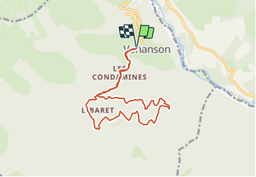

Length
8.5 km

Max alt
1292 m

Uphill gradient
556 m
Km-Effort
15.9 km

Min alt
975 m

Downhill gradient
549 m
Boucle
Yes
Creation date :
2023-07-24 12:47:26.096
Updated on :
2023-07-24 12:48:28.629
3h36
Difficulty : Medium

FREE GPS app for hiking
 SityTrail
IGN / Geographical institutes
SityTrail Plus
The world is yours!
About
Trail Walking of 8.5 km to be discovered at Provence-Alpes-Côte d'Azur, Maritime Alps, Venanson. This trail is proposed by Benteux.
Description
MARCCHE
Positioning
Country:
France
Region :
Provence-Alpes-Côte d'Azur
Department/Province :
Maritime Alps
Municipality :
Venanson
Location:
Unknown
Start:(Dec)
Start:(UTM)
359925 ; 4879253 (32T) N.
Comments