


Rondje Arleux Oost

FreddyTuerlinckx
User
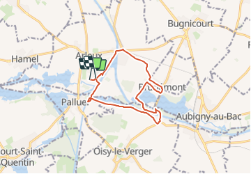

Length
11 km

Max alt
46 m

Uphill gradient
53 m
Km-Effort
11.7 km

Min alt
33 m

Downhill gradient
52 m
Boucle
No
Creation date :
2023-07-25 06:05:06.669
Updated on :
2023-08-11 14:29:23.843
2h38
Difficulty : Easy

FREE GPS app for hiking
 SityTrail
IGN / Geographical institutes
SityTrail Plus
The world is yours!
About
Trail On foot of 11 km to be discovered at Hauts-de-France, Nord, Arleux. This trail is proposed by FreddyTuerlinckx.
Positioning
Country:
France
Region :
Hauts-de-France
Department/Province :
Nord
Municipality :
Arleux
Location:
Unknown
Start:(Dec)
Start:(UTM)
507529 ; 5569087 (31U) N.
Comments