Trail Walking Bey - P . Bey - Orain - La Chaunée - Croix Rambaud - La Serée et retour par les Perreuils.s. - Photo

P . Bey - Orain - La Chaunée - Croix Rambaud - La Serée et retour par les Perreuils.s.

© OpenStreetMap contributors
Length
Length
9.3 km
Max alt
Max alt
213 m
Uphill gradient
Uphill gradient
76 m
Km-Effort
Km-Effort  
10.3 km
Min alt
Min alt
178 m
Downhill gradient
Downhill gradient
76 m
Boucle
Boucle
Yes
Creation date :
2023-07-25 08:13:15.472
Updated on :
2023-07-25 08:18:12.33

(0 Reviews)

Walking
Walking
2h20
Difficulty : Medium

Scan this QR Code to open this trail in the SityTrail application

FREE GPS app for hiking

Logo SityTrail SityTrail

IGN / Geographical institutes

Download SityTrail from the App Store Download SityTrail from Google Play

Logo SityTrail SityTrail World

The world is yours!

Download SityTrail from the App Store Download SityTrail from Google Play Download SityTrail on Huawei AppGallery

About

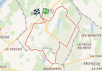
Trail Walking of 9.3 km to be discovered at Bourgogne-Franche-Comté, Saône-et-Loire, Bey. This trail is proposed by jeanpaulcheyssac.

Description

Départ : Parking salle des fêtes le long de la D 673 .

Elevation profile

Positioning

Country:
France
Region :
Bourgogne-Franche-Comté
Department/Province :
Saône-et-Loire
Municipality :
Bey
Location:
Unknown
Start:(UTM)
650057 ; 5186956 (31T) N.

Trails nearby

Trail Walking Sassenay - sassenay - Photo
Walking
Guytou71

Walking

Medium
Sassenay, Bourgogne-Franche-Comté, Saône-et-Loire, France
7 km | 7.5 km-effort
1h 41min
Yes
Trail Walking Allériot - P . Allériot - Serrey - Traverser D 673 - Prondevaux - Re traverser D 673 et retour par le bourg .  - Photo
Walking
jeanpaulcheyssac

Walking

Medium
Allériot, Bourgogne-Franche-Comté, Saône-et-Loire, France
8.4 km | 9.5 km-effort
2h 9min
Yes
Trail Walking Montcoy - P . Montcoy - Les Genettes - Bois de la mousse- Orain - Bey - Le Pommeray - Champ Failly et retour .  - Photo
Walking
jeanpaulcheyssac

Walking

Medium
Montcoy, Bourgogne-Franche-Comté, Saône-et-Loire, France
9.3 km | 10.3 km-effort
2h 20min
Yes
Trail Walking Montcoy - G . Montcoy - D35 - le chateau - La tirre - La GD Taule - La Louere et retour  - Photo
Walking
jeanpaulcheyssac

Walking

Difficult
Montcoy, Bourgogne-Franche-Comté, Saône-et-Loire, France
12.3 km | 13.5 km-effort
3h 4min
Yes
Trail Walking Oslon - TP . Oslon -Chatenoy en Bresse -Pré meillot - le Gallois et retour  - Photo
Walking
jeanpaulcheyssac

Walking

Easy
Oslon, Bourgogne-Franche-Comté, Saône-et-Loire, France
4.4 km | 4.6 km-effort
1h 3min
Yes
Trail Walking Montcoy - P . Montcoy - le Chateau - Croisée des allées - Le Paroy et retyour  - Photo
Walking
jeanpaulcheyssac

Walking

Medium
(1)
Montcoy, Bourgogne-Franche-Comté, Saône-et-Loire, France
6.1 km | 6.9 km-effort
1h 33min
Yes
Trail Walking Montcoy - P . Montcoy - le Chateau - la GD taule - la Louère -et retour . - Photo
Walking
jeanpaulcheyssac

Walking

Medium
Montcoy, Bourgogne-Franche-Comté, Saône-et-Loire, France
8.6 km | 9.5 km-effort
2h 9min
Yes
Trail Walking Bey - P . Bey - la Saone - Alleriot - les Tientes - la vigne et retour  - Photo
Walking
jeanpaulcheyssac

Walking

Medium
Bey, Bourgogne-Franche-Comté, Saône-et-Loire, France
7.9 km | 8.6 km-effort
1h 56min
Yes
Trail Walking Allériot - G. Alleriot - Chatenoy en Bresse - Oslon - Prondevaux et retour. - Photo
Walking
jeanpaulcheyssac

Walking

Medium
Allériot, Bourgogne-Franche-Comté, Saône-et-Loire, France
10 km | 11.1 km-effort
2h 30min
Yes


Close
My subscriptions