


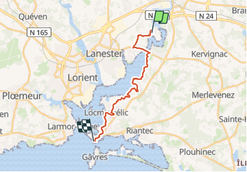
Hennebont Port Louis

jackalv
User

Length
17.2 km

Max alt
47 m

Uphill gradient
227 m
Km-Effort
20 km

Min alt
-2 m

Downhill gradient
233 m
Boucle
No
Creation date :
2023-07-25 09:34:31.468
Updated on :
2023-07-25 17:04:57.293
7h11
Difficulty : Easy

FREE GPS app for hiking
 SityTrail
IGN / Geographical institutes
SityTrail Plus
The world is yours!
About
Trail Walking of 17.2 km to be discovered at Brittany, Morbihan, Lanester. This trail is proposed by jackalv.
Positioning
Country:
France
Region :
Brittany
Department/Province :
Morbihan
Municipality :
Lanester
Location:
Unknown
Start:(Dec)
Start:(UTM)
477789 ; 5291602 (30T) N.
Comments