


cascades de nevache

lygi
User
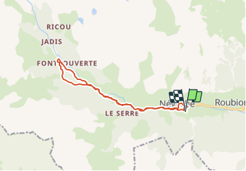

Length
13.1 km

Max alt
1994 m

Uphill gradient
506 m
Km-Effort
19.9 km

Min alt
1595 m

Downhill gradient
510 m
Boucle
Yes
Creation date :
2023-07-26 13:07:05.162
Updated on :
2023-07-26 13:08:41.191
4h31
Difficulty : Easy
4h31
Difficulty : Very difficult

FREE GPS app for hiking
 SityTrail
IGN / Geographical institutes
SityTrail Plus
The world is yours!
About
Trail On foot of 13.1 km to be discovered at Provence-Alpes-Côte d'Azur, Hautes-Alpes, Névache. This trail is proposed by lygi.
Positioning
Country:
France
Region :
Provence-Alpes-Côte d'Azur
Department/Province :
Hautes-Alpes
Municipality :
Névache
Location:
Unknown
Start:(Dec)
Start:(UTM)
311549 ; 4987538 (32T) N.
Comments