


;depart mont de laval

gerardmicheline
User
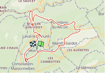

Length
22 km

Max alt
942 m

Uphill gradient
867 m
Km-Effort
34 km

Min alt
455 m

Downhill gradient
866 m
Boucle
Yes
Creation date :
2023-07-28 13:06:59.641
Updated on :
2023-07-28 13:07:41.552
7h42
Difficulty : Very difficult

FREE GPS app for hiking
 SityTrail
IGN / Geographical institutes
SityTrail Plus
The world is yours!
About
Trail Walking of 22 km to be discovered at Bourgogne-Franche-Comté, Doubs, Mont-de-Laval. This trail is proposed by gerardmicheline.
Positioning
Country:
France
Region :
Bourgogne-Franche-Comté
Department/Province :
Doubs
Municipality :
Mont-de-Laval
Location:
Unknown
Start:(Dec)
Start:(UTM)
319816 ; 5226804 (32T) N.
Comments