
fraipont_banneux

Mullender
User
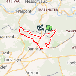

Length
9.9 km

Max alt
322 m

Uphill gradient
224 m
Km-Effort
12.8 km

Min alt
174 m

Downhill gradient
216 m
Boucle
Yes
Creation date :
2015-01-05 00:00:00.0
Updated on :
2015-01-05 00:00:00.0
2h02
Difficulty : Easy

FREE GPS app for hiking
 SityTrail
IGN / Geographical institutes
SityTrail Plus
The world is yours!
About
Trail Walking of 9.9 km to be discovered at Wallonia, Liège, Sprimont. This trail is proposed by Mullender.
Photos


Positioning
Country:
Belgium
Region :
Wallonia
Department/Province :
Liège
Municipality :
Sprimont
Location:
Louveigné
Start:(Dec)
Start:(UTM)
694635 ; 5603268 (31U) N.
Comments