


2023-07-29_07h59m27_Boucle_de_Mont_a_Cazaux_Frechet

jpb83
User
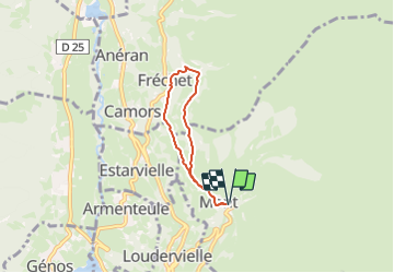

Length
4.8 km

Max alt
1304 m

Uphill gradient
202 m
Km-Effort
7.5 km

Min alt
1128 m

Downhill gradient
203 m
Boucle
Yes
Creation date :
2023-07-29 05:59:27.445
Updated on :
2023-07-29 06:02:30.606
1h42
Difficulty : Medium

FREE GPS app for hiking
 SityTrail
IGN / Geographical institutes
SityTrail Plus
The world is yours!
About
Trail Walking of 4.8 km to be discovered at Occitania, Hautespyrenees, Mont. This trail is proposed by jpb83.
Positioning
Country:
France
Region :
Occitania
Department/Province :
Hautespyrenees
Municipality :
Mont
Location:
Unknown
Start:(Dec)
Start:(UTM)
289913 ; 4743577 (31T) N.
Comments