


Aout032023GP

FPortier
User
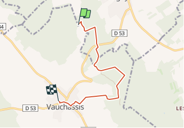

Length
5 km

Max alt
273 m

Uphill gradient
78 m
Km-Effort
6.1 km

Min alt
183 m

Downhill gradient
106 m
Boucle
No
Creation date :
2023-07-30 08:48:36.68
Updated on :
2023-07-30 08:50:25.548
1h22
Difficulty : Medium

FREE GPS app for hiking
 SityTrail
IGN / Geographical institutes
SityTrail Plus
The world is yours!
About
Trail Walking of 5 km to be discovered at Grand Est, Aube, Prugny. This trail is proposed by FPortier.
Positioning
Country:
France
Region :
Grand Est
Department/Province :
Aube
Municipality :
Prugny
Location:
Unknown
Start:(Dec)
Start:(UTM)
568953 ; 5343330 (31U) N.
Comments