


Balade lac guerkedan

uyuniness
User
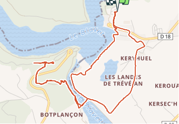

Length
7.5 km

Max alt
185 m

Uphill gradient
223 m
Km-Effort
10.4 km

Min alt
83 m

Downhill gradient
223 m
Boucle
Yes
Creation date :
2023-07-15 13:05:45.0
Updated on :
2023-07-30 10:43:13.545
2h12
Difficulty : Unknown

FREE GPS app for hiking
 SityTrail
IGN / Geographical institutes
SityTrail Plus
The world is yours!
About
Trail Walking of 7.5 km to be discovered at Brittany, Côtes-d'Armor, Guerlédan. This trail is proposed by uyuniness.
Description
Balade 7. 5 kms
Positioning
Country:
France
Region :
Brittany
Department/Province :
Côtes-d'Armor
Municipality :
Guerlédan
Location:
Mûr-de-Bretagne
Start:(Dec)
Start:(UTM)
499105 ; 5338561 (30U) N.
Comments