


2023-07-30_15h33m03_La_sapiniere_de_Balestas

jpb83
User
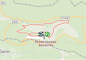

Length
4.9 km

Max alt
1581 m

Uphill gradient
234 m
Km-Effort
8 km

Min alt
1392 m

Downhill gradient
235 m
Boucle
Yes
Creation date :
2023-07-30 13:33:04.0
Updated on :
2023-07-30 13:37:37.677
1h49
Difficulty : Medium

FREE GPS app for hiking
 SityTrail
IGN / Geographical institutes
SityTrail Plus
The world is yours!
About
Trail Walking of 4.9 km to be discovered at Occitania, Hautespyrenees, Loudervielle. This trail is proposed by jpb83.
Positioning
Country:
France
Region :
Occitania
Department/Province :
Hautespyrenees
Municipality :
Loudervielle
Location:
Unknown
Start:(Dec)
Start:(UTM)
290650 ; 4741365 (31T) N.
Comments