


SityTrail - le Pilon

affinetataille
User GUIDE
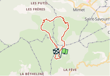

Length
13.7 km

Max alt
657 m

Uphill gradient
481 m
Km-Effort
20 km

Min alt
271 m

Downhill gradient
481 m
Boucle
Yes
Creation date :
2023-07-31 13:58:27.275
Updated on :
2024-11-15 01:14:40.147
6h00
Difficulty : Medium

FREE GPS app for hiking
 SityTrail
IGN / Geographical institutes
SityTrail Plus
The world is yours!
About
Trail Walking of 13.7 km to be discovered at Provence-Alpes-Côte d'Azur, Bouches-du-Rhône, Allauch. This trail is proposed by affinetataille.
Description
Parking chemin des Gages Allauch
Photos


38 photos in total. Please click on a photo to see them all in the gallery.
Positioning
Country:
France
Region :
Provence-Alpes-Côte d'Azur
Department/Province :
Bouches-du-Rhône
Municipality :
Allauch
Location:
Unknown
Start:(Dec)
Start:(UTM)
701234 ; 4805359 (31T) N.
Comments