Trail Cycle Aubenas-les-Alpes - Parcours n°14 - Aubenas-les-Alpes - Photo

Randonnées de Vélo Loisir Provence GUIDE+

© OpenStreetMap contributors
Length
Length
42 km
Max alt
Max alt
785 m
Uphill gradient
Uphill gradient
872 m
Km-Effort
Km-Effort  
54 km
Min alt
Min alt
384 m
Downhill gradient
Downhill gradient
876 m
Boucle
Boucle
Yes
Creation date :
2015-01-07 00:00:00.0
Updated on :
2015-01-07 00:00:00.0

(0 Reviews)

Cycle
Cycle
3h03
Difficulty : Difficult

Scan this QR Code to open this trail in the SityTrail application

FREE GPS app for hiking

Logo SityTrail SityTrail

IGN / Geographical institutes

Download SityTrail from the App Store Download SityTrail from Google Play

Logo SityTrail SityTrail World

The world is yours!

Download SityTrail from the App Store Download SityTrail from Google Play Download SityTrail on Huawei AppGallery

About

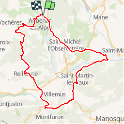
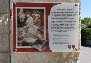
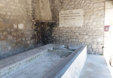
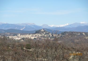
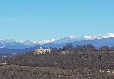
Trail Cycle of 42 km to be discovered at Provence-Alpes-Côte d'Azur, Alpes-de-Haute-Provence, Aubenas-les-Alpes. This trail is proposed by Vélo Loisir Provence.

Description

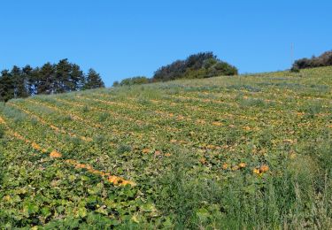
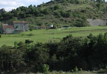
A large loop in the heart of the Pays de Forcalquier among fields of lavender and poppies. You will also cross some charming villages during your ride. Direction of the itinerary : Aubenas-les-Alpes => Reillanne => Saint-Martin-des-Eaux => Dauphin => Saint-Michel-l’observatoire => Aubenas-les-Alpes

Elevation profile

Photos

Positioning

Country:
France
Region :
Provence-Alpes-Côte d'Azur
Department/Province :
Alpes-de-Haute-Provence
Municipality :
Aubenas-les-Alpes
Location:
Unknown
Start:(UTM)
715539 ; 4868601 (31T) N.

Trails nearby

Trail Walking Saint-Michel-l'Observatoire - st.michel l observatoire. les deux chapelles.  - Photo
Walking
Roger

Walking

Very easy
Saint-Michel-l'Observatoire, Provence-Alpes-Côte d'Azur, Alpes-de-Haute-Provence, France
4 km | 5.2 km-effort
1h 19min
Yes
Trail Walking Saint-Michel-l'Observatoire - Saint Michel l'observatoire - Photo
Walking
liocol

Walking

Easy
(1)
Saint-Michel-l'Observatoire, Provence-Alpes-Côte d'Azur, Alpes-de-Haute-Provence, France
6.1 km | 7.9 km-effort
2h 3min
Yes
Trail Walking Saint-Michel-l'Observatoire - St Michel l'observatoire, chapelle St. Jean et tour de Porchères - Photo
Walking
Daniel.BRUN-PICARD

Walking

Easy
Saint-Michel-l'Observatoire, Provence-Alpes-Côte d'Azur, Alpes-de-Haute-Provence, France
8.1 km | 10.6 km-effort
2h 28min
Yes
Trail Walking Vachères - Vachères 04 - Photo
Walking
janussity

Walking

Difficult
Vachères, Provence-Alpes-Côte d'Azur, Alpes-de-Haute-Provence, France
17.8 km | 25 km-effort
4h 47min
Yes
Trail Walking Saint-Michel-l'Observatoire - CR_Domitia_BH_06_St-Michel-Obs_Forcalquier_20160908 - Photo
Walking
patrickdanilo

Walking

Medium
Saint-Michel-l'Observatoire, Provence-Alpes-Côte d'Azur, Alpes-de-Haute-Provence, France
10.3 km | 14 km-effort
2h 59min
No
Trail Cycle Aubenas-les-Alpes - Parcours n°13 - Aubenas-les-Alpes - Photo
Cycle
GUIDE+

Cycle

Medium
Aubenas-les-Alpes, Provence-Alpes-Côte d'Azur, Alpes-de-Haute-Provence, France
24 km | 30 km-effort
1h 44min
Yes
Trail Walking Saint-Michel-l'Observatoire - St Michel l’Oservatoore - Photo
Walking
aubr

Walking

Medium
Saint-Michel-l'Observatoire, Provence-Alpes-Côte d'Azur, Alpes-de-Haute-Provence, France
9 km | 11.7 km-effort
2h 33min
Yes
Trail Walking Saint-Michel-l'Observatoire - Chapelle Saint Jean de Fuzils - La Tour de Porchères - Photo
Walking
Duc Vi Khai

Walking

Medium
Saint-Michel-l'Observatoire, Provence-Alpes-Côte d'Azur, Alpes-de-Haute-Provence, France
22 km | 28 km-effort
2h 50min
No
Trail Walking Saint-Michel-l'Observatoire - St Michel, la Chapelle St Jean et la tour Porchère - Photo
Walking
liocol

Walking

Easy
Saint-Michel-l'Observatoire, Provence-Alpes-Côte d'Azur, Alpes-de-Haute-Provence, France
7.7 km | 9.8 km-effort
2h 50min
Yes


Close
My subscriptions