Trail Cycle Mérindol - 
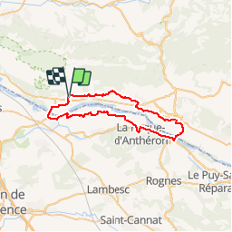
Parcours n°26 - Mérindol - Photo

Randonnées de Vélo Loisir Provence GUIDE+

© OpenStreetMap contributors
Length
Length
46 km
Max alt
Max alt
213 m
Uphill gradient
Uphill gradient
435 m
Km-Effort
Km-Effort  
51 km
Min alt
Min alt
109 m
Downhill gradient
Downhill gradient
439 m
Boucle
Boucle
Yes
Creation date :
2015-01-07 00:00:00.0
Updated on :
2015-01-07 00:00:00.0

(1 Reviews)

Cycle
Cycle
2h57
Difficulty : Easy

Scan this QR Code to open this trail in the SityTrail application

FREE GPS app for hiking

Logo SityTrail SityTrail

IGN / Geographical institutes

Download SityTrail from the App Store Download SityTrail from Google Play

Logo SityTrail SityTrail Plus

The world is yours!

Download SityTrail from the App Store Download SityTrail from Google Play Download SityTrail on Huawei AppGallery

About

Trail Cycle of 46 km to be discovered at Provence-Alpes-Côte d'Azur, Vaucluse, Mérindol. This trail is proposed by Vélo Loisir Provence.

Description

A ride among the landscape of the Durance valley at everybody’s reach. Direction of the itinerary : Mérindol => Lauris => Cadenet => La Roque d’Anthéron => Mallemort => Mérindol

Elevation profile

Photos

Positioning

Country:
France
Region :
Provence-Alpes-Côte d'Azur
Department/Province :
Vaucluse
Municipality :
Mérindol
Location:
Unknown
Start:(UTM)
677446 ; 4847133 (31T) N.

Comments

Please log in to post a review or rate the element


Beau parcours. Avec peu de tronçons exposés à la circulation. Peu de dénivelé dans la vallée mais venteux. Belle variété. 4/5.


Close
My subscriptions