


01/08/2023 - ST ANDRE DES EAUX, d'est en ouest.Virtuel

babeth35
User
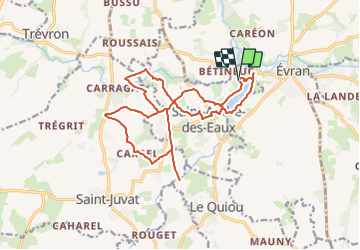

Length
17.6 km

Max alt
47 m

Uphill gradient
107 m
Km-Effort
19.1 km

Min alt
10 m

Downhill gradient
107 m
Boucle
Yes
Creation date :
2023-08-01 12:38:52.92
Updated on :
2023-08-01 12:52:08.08
4h19
Difficulty : Easy
4h19
Difficulty : Very difficult

FREE GPS app for hiking
 SityTrail
IGN / Geographical institutes
SityTrail Plus
The world is yours!
About
Trail On foot of 17.6 km to be discovered at Brittany, Côtes-d'Armor, Saint-André-des-Eaux. This trail is proposed by babeth35.
Positioning
Country:
France
Region :
Brittany
Department/Province :
Côtes-d'Armor
Municipality :
Saint-André-des-Eaux
Location:
Unknown
Start:(Dec)
Start:(UTM)
574168 ; 5359004 (30U) N.
Comments