


Parc et rue

charpe
User
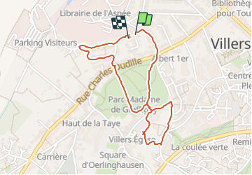

Length
1.9 km

Max alt
290 m

Uphill gradient
45 m
Km-Effort
2.5 km

Min alt
255 m

Downhill gradient
39 m
Boucle
Yes
Creation date :
2023-08-01 15:21:24.0
Updated on :
2023-08-01 16:03:00.298
41m
Difficulty : Easy

FREE GPS app for hiking
 SityTrail
IGN / Geographical institutes
SityTrail Plus
The world is yours!
About
Trail Walking of 1.9 km to be discovered at Grand Est, Meurthe-et-Moselle, Villers-lès-Nancy. This trail is proposed by charpe.
Positioning
Country:
France
Region :
Grand Est
Department/Province :
Meurthe-et-Moselle
Municipality :
Villers-lès-Nancy
Location:
Unknown
Start:(Dec)
Start:(UTM)
289877 ; 5395090 (32U) N.
Comments