


Tour du Rocher de Turon depuis Combovin par le Pas de Fontfène

Lucquiaud
User
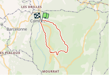

Length
9.9 km

Max alt
902 m

Uphill gradient
555 m
Km-Effort
17.3 km

Min alt
366 m

Downhill gradient
557 m
Boucle
Yes
Creation date :
2023-08-01 17:06:52.897
Updated on :
2023-08-01 17:08:44.677
3h56
Difficulty : Difficult

FREE GPS app for hiking
 SityTrail
IGN / Geographical institutes
SityTrail Plus
The world is yours!
About
Trail Walking of 9.9 km to be discovered at Auvergne-Rhône-Alpes, Drôme, Combovin. This trail is proposed by Lucquiaud.
Points of interest


Positioning
Country:
France
Region :
Auvergne-Rhône-Alpes
Department/Province :
Drôme
Municipality :
Combovin
Location:
Unknown
Start:(Dec)
Start:(UTM)
664222 ; 4971073 (31T) N.
Comments