


Allemond Le Raffour

kephas
User
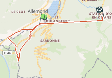

Length
8.7 km

Max alt
1488 m

Uphill gradient
997 m
Km-Effort
19.8 km

Min alt
714 m

Downhill gradient
335 m
Boucle
No
Creation date :
2023-08-02 07:23:23.066
Updated on :
2023-08-02 10:02:47.766
2h38
Difficulty : Easy

FREE GPS app for hiking
 SityTrail
IGN / Geographical institutes
SityTrail Plus
The world is yours!
About
Trail Walking of 8.7 km to be discovered at Auvergne-Rhône-Alpes, Isère, Allemond. This trail is proposed by kephas.
Description
Balade en sous-bois
Positioning
Country:
France
Region :
Auvergne-Rhône-Alpes
Department/Province :
Isère
Municipality :
Allemond
Location:
Unknown
Start:(Dec)
Start:(UTM)
267068 ; 5001225 (32T) N.
Comments