


Footing par belvédère de ronzon

nanard223
User
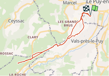

Length
9.9 km

Max alt
865 m

Uphill gradient
235 m
Km-Effort
13.1 km

Min alt
667 m

Downhill gradient
238 m
Boucle
Yes
Creation date :
2023-07-31 05:35:42.321
Updated on :
2023-08-02 13:16:22.651
1h15
Difficulty : Medium

FREE GPS app for hiking
 SityTrail
IGN / Geographical institutes
SityTrail Plus
The world is yours!
About
Trail Running of 9.9 km to be discovered at Auvergne-Rhône-Alpes, Haute-Loire, Le Puy-en-Velay. This trail is proposed by nanard223.
Positioning
Country:
France
Region :
Auvergne-Rhône-Alpes
Department/Province :
Haute-Loire
Municipality :
Le Puy-en-Velay
Location:
Unknown
Start:(Dec)
Start:(UTM)
569130 ; 4987805 (31T) N.
Comments