


Lac du Lauzanier

Clo0413
User
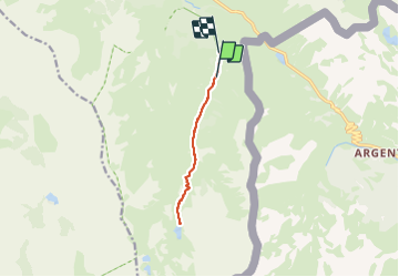

Length
9.8 km

Max alt
2291 m

Uphill gradient
395 m
Km-Effort
15.1 km

Min alt
1904 m

Downhill gradient
416 m
Boucle
No
Creation date :
2023-08-02 08:44:01.146
Updated on :
2023-08-05 20:33:59.323
2h52
Difficulty : Medium

FREE GPS app for hiking
 SityTrail
IGN / Geographical institutes
SityTrail Plus
The world is yours!
About
Trail Walking of 9.8 km to be discovered at Provence-Alpes-Côte d'Azur, Alpes-de-Haute-Provence, Val-d'Oronaye. This trail is proposed by Clo0413.
Positioning
Country:
France
Region :
Provence-Alpes-Côte d'Azur
Department/Province :
Alpes-de-Haute-Provence
Municipality :
Val-d'Oronaye
Location:
Larche
Start:(Dec)
Start:(UTM)
331542 ; 4919904 (32T) N.
Comments