


2023-08-03_17h55m52_13 le-canal-des-2-mers-a-velo-moissac-montauban

chasle
User
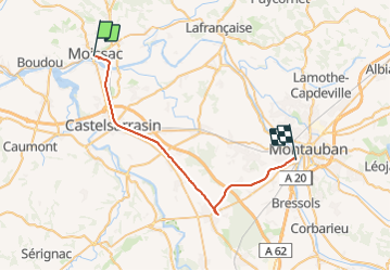

Length
34 km

Max alt
111 m

Uphill gradient
188 m
Km-Effort
37 km

Min alt
65 m

Downhill gradient
171 m
Boucle
No
Creation date :
2023-08-03 15:55:52.735
Updated on :
2023-08-03 15:55:56.717

FREE GPS app for hiking
 SityTrail
IGN / Geographical institutes
SityTrail Plus
The world is yours!
About
Trail of 34 km to be discovered at Occitania, Tarn-et-Garonne, Moissac. This trail is proposed by chasle.
Positioning
Country:
France
Region :
Occitania
Department/Province :
Tarn-et-Garonne
Municipality :
Moissac
Location:
Unknown
Start:(Dec)
Start:(UTM)
346564 ; 4885030 (31T) N.
Comments