


Pont de Lariane - Chalet des amoureux

rochedaniel
User
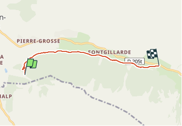

Length
4.4 km

Max alt
2024 m

Uphill gradient
100 m
Km-Effort
5.7 km

Min alt
1947 m

Downhill gradient
66 m
Boucle
No
Creation date :
2023-08-03 14:40:57.0
Updated on :
2023-08-03 17:08:12.096
1h17
Difficulty : Easy

FREE GPS app for hiking
 SityTrail
IGN / Geographical institutes
SityTrail Plus
The world is yours!
About
Trail Walking of 4.4 km to be discovered at Provence-Alpes-Côte d'Azur, Hautes-Alpes, Molines-en-Queyras. This trail is proposed by rochedaniel.
Description
Promenade aller et retour de 8,8 km au total.
Positioning
Country:
France
Region :
Provence-Alpes-Côte d'Azur
Department/Province :
Hautes-Alpes
Municipality :
Molines-en-Queyras
Location:
Unknown
Start:(Dec)
Start:(UTM)
330370 ; 4953717 (32T) N.
Comments