


2023-08-04_11h04m05_ParcoursDodentocht2023

mumu.larandonneuse
User GUIDE
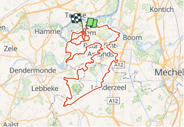

Length
103 km

Max alt
31 m

Uphill gradient
453 m
Km-Effort
109 km

Min alt
-4 m

Downhill gradient
448 m
Boucle
No
Creation date :
2023-08-04 09:04:05.328
Updated on :
2023-08-16 07:56:57.957
24h49
Difficulty : Very difficult

FREE GPS app for hiking
 SityTrail
IGN / Geographical institutes
SityTrail Plus
The world is yours!
About
Trail Walking of 103 km to be discovered at Flanders, Antwerp, Bornem. This trail is proposed by mumu.larandonneuse.
Description
Positioning
Country:
Belgium
Region :
Flanders
Department/Province :
Antwerp
Municipality :
Bornem
Location:
Bornem
Start:(Dec)
Start:(UTM)
586757 ; 5660828 (31U) N.
Comments