


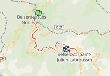
Les Nonières - Saint-Julien

frizou83
User

Length
4.7 km

Max alt
806 m

Uphill gradient
209 m
Km-Effort
7.2 km

Min alt
674 m

Downhill gradient
116 m
Boucle
No
Creation date :
2023-08-04 09:09:19.249
Updated on :
2023-08-04 09:10:03.975
1h38
Difficulty : Medium

FREE GPS app for hiking
 SityTrail
IGN / Geographical institutes
SityTrail Plus
The world is yours!
About
Trail Walking of 4.7 km to be discovered at Auvergne-Rhône-Alpes, Ardèche, Belsentes. This trail is proposed by frizou83.
Positioning
Country:
France
Region :
Auvergne-Rhône-Alpes
Department/Province :
Ardèche
Municipality :
Belsentes
Location:
Nonières
Start:(Dec)
Start:(UTM)
617340 ; 4976564 (31T) N.
Comments