


Superdevoluy 》 Chalet du Vallon d'Ane

qlqin
User
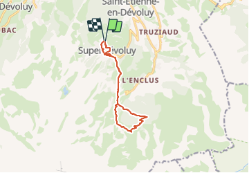

Length
11.1 km

Max alt
1776 m

Uphill gradient
398 m
Km-Effort
16.4 km

Min alt
1474 m

Downhill gradient
399 m
Boucle
Yes
Creation date :
2023-08-04 07:44:18.492
Updated on :
2023-08-04 11:54:47.121
3h47
Difficulty : Difficult

FREE GPS app for hiking
 SityTrail
IGN / Geographical institutes
SityTrail Plus
The world is yours!
About
Trail Walking of 11.1 km to be discovered at Provence-Alpes-Côte d'Azur, Hautes-Alpes, Le Dévoluy. This trail is proposed by qlqin.
Positioning
Country:
France
Region :
Provence-Alpes-Côte d'Azur
Department/Province :
Hautes-Alpes
Municipality :
Le Dévoluy
Location:
Saint-Étienne-en-Dévoluy
Start:(Dec)
Start:(UTM)
732108 ; 4951540 (31T) N.
Comments