


Rando Metabief Mont d'Or

Fab-Oz
User
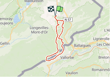

Length
25 km

Max alt
1451 m

Uphill gradient
1010 m
Km-Effort
39 km

Min alt
947 m

Downhill gradient
1009 m
Boucle
Yes
Creation date :
2023-08-05 07:28:29.7
Updated on :
2023-08-05 16:53:43.005
5h40
Difficulty : Difficult

FREE GPS app for hiking
 SityTrail
IGN / Geographical institutes
SityTrail Plus
The world is yours!
About
Trail Walking of 25 km to be discovered at Bourgogne-Franche-Comté, Doubs, Métabief. This trail is proposed by Fab-Oz.
Positioning
Country:
France
Region :
Bourgogne-Franche-Comté
Department/Province :
Doubs
Municipality :
Métabief
Location:
Unknown
Start:(Dec)
Start:(UTM)
297904 ; 5183641 (32T) N.
Comments