


javernant

FPortier
User
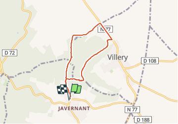

Length
5.8 km

Max alt
299 m

Uphill gradient
190 m
Km-Effort
8.3 km

Min alt
174 m

Downhill gradient
190 m
Boucle
Yes
Creation date :
2023-07-20 07:09:26.692
Updated on :
2023-08-05 17:16:12.903
2h17
Difficulty : Easy

FREE GPS app for hiking
 SityTrail
IGN / Geographical institutes
SityTrail Plus
The world is yours!
About
Trail Walking of 5.8 km to be discovered at Grand Est, Aube, Javernant. This trail is proposed by FPortier.
Positioning
Country:
France
Region :
Grand Est
Department/Province :
Aube
Municipality :
Javernant
Location:
Unknown
Start:(Dec)
Start:(UTM)
574458 ; 5334834 (31U) N.
Comments