


Puy de Dôme - Puy du Pariou

Fabichette
User
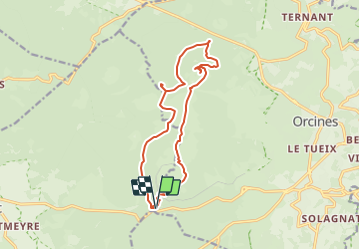

Length
14.8 km

Max alt
1416 m

Uphill gradient
695 m
Km-Effort
24 km

Min alt
1024 m

Downhill gradient
695 m
Boucle
Yes
Creation date :
2023-08-06 08:27:54.928
Updated on :
2023-08-06 08:29:51.952
5h28
Difficulty : Very difficult

FREE GPS app for hiking
 SityTrail
IGN / Geographical institutes
SityTrail Plus
The world is yours!
About
Trail Walking of 14.8 km to be discovered at Auvergne-Rhône-Alpes, Puy-de-Dôme, Orcines. This trail is proposed by Fabichette.
Positioning
Country:
France
Region :
Auvergne-Rhône-Alpes
Department/Province :
Puy-de-Dôme
Municipality :
Orcines
Location:
Unknown
Start:(Dec)
Start:(UTM)
496643 ; 5067867 (31T) N.
Comments