


St Amans Ribonnet

pidjam
User
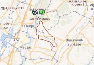

Length
9 km

Max alt
296 m

Uphill gradient
219 m
Km-Effort
12 km

Min alt
191 m

Downhill gradient
215 m
Boucle
Yes
Creation date :
2023-08-06 06:49:47.627
Updated on :
2023-08-31 14:01:46.692
2h11
Difficulty : Medium

FREE GPS app for hiking
 SityTrail
IGN / Geographical institutes
SityTrail Plus
The world is yours!
About
Trail Walking of 9 km to be discovered at Occitania, Haute-Garonne, Muret. This trail is proposed by pidjam.
Positioning
Country:
France
Region :
Occitania
Department/Province :
Haute-Garonne
Municipality :
Muret
Location:
Unknown
Start:(Dec)
Start:(UTM)
363236 ; 4807041 (31T) N.
Comments