


Col de l’Homme mort le Saint Guiral

boudpn
User
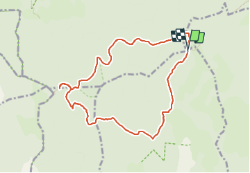

Length
9.9 km

Max alt
1336 m

Uphill gradient
231 m
Km-Effort
13 km

Min alt
1182 m

Downhill gradient
231 m
Boucle
Yes
Creation date :
2023-08-06 07:40:47.0
Updated on :
2023-08-06 11:52:57.67
4h11
Difficulty : Difficult

FREE GPS app for hiking
 SityTrail
IGN / Geographical institutes
SityTrail Plus
The world is yours!
About
Trail Walking of 9.9 km to be discovered at Occitania, Gard, Arrigas. This trail is proposed by boudpn.
Description
Très facile
Photos


Positioning
Country:
France
Region :
Occitania
Department/Province :
Gard
Municipality :
Arrigas
Location:
Unknown
Start:(Dec)
Start:(UTM)
538887 ; 4875212 (31T) N.
Comments