


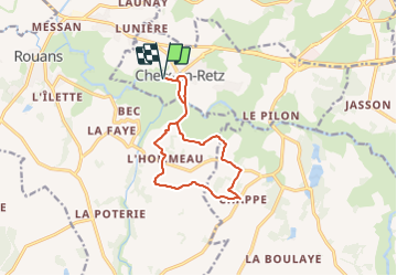
CHEIX-Chappe

JEFFV
User

Length
11.2 km

Max alt
40 m

Uphill gradient
84 m
Km-Effort
12.3 km

Min alt
0 m

Downhill gradient
84 m
Boucle
Yes
Creation date :
2023-08-06 16:27:47.711
Updated on :
2023-08-06 16:28:25.696
2h48
Difficulty : Difficult

FREE GPS app for hiking
 SityTrail
IGN / Geographical institutes
SityTrail Plus
The world is yours!
About
Trail Walking of 11.2 km to be discovered at Pays de la Loire, Loire-Atlantique, Cheix-en-Retz. This trail is proposed by JEFFV.
Positioning
Country:
France
Region :
Pays de la Loire
Department/Province :
Loire-Atlantique
Municipality :
Cheix-en-Retz
Location:
Unknown
Start:(Dec)
Start:(UTM)
589347 ; 5225928 (30T) N.
Comments