


ViIOLAY "Tour de Matagrin" 16 km - 500 m

Thomasdanielle
User
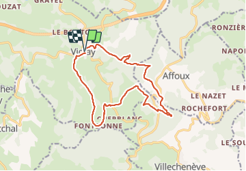

Length
15.8 km

Max alt
1005 m

Uphill gradient
504 m
Km-Effort
23 km

Min alt
632 m

Downhill gradient
510 m
Boucle
Yes
Creation date :
2023-08-07 07:03:53.0
Updated on :
2023-08-09 10:00:52.301
5h07
Difficulty : Very difficult

FREE GPS app for hiking
 SityTrail
IGN / Geographical institutes
SityTrail Plus
The world is yours!
About
Trail Walking of 15.8 km to be discovered at Auvergne-Rhône-Alpes, Loire, Violay. This trail is proposed by Thomasdanielle.
Description
D/A : Parking de la mairie
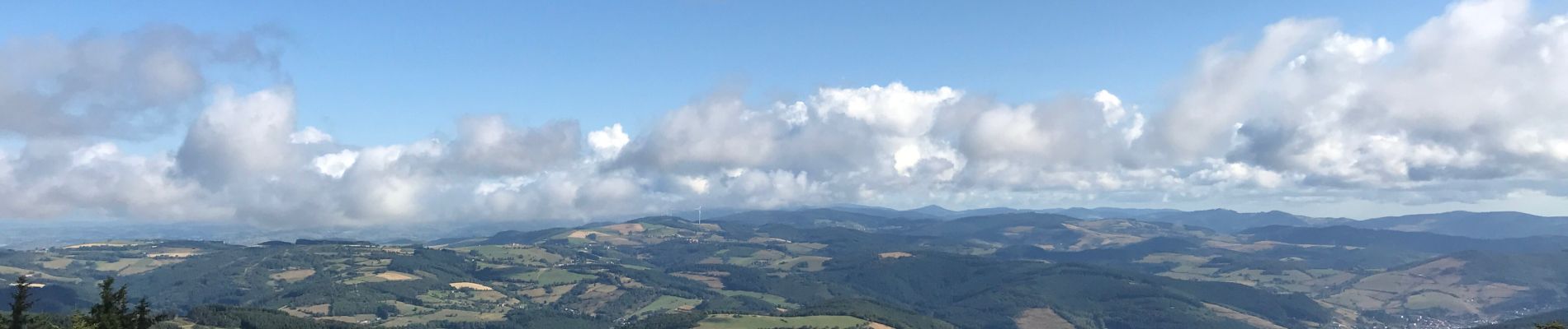
Photos
"
data-pinterest-text="Pin it"
data-tweet-text="share on twitter"
data-facebook-share-url="https://www.sitytrail.com/en/trails/3762200-violay--viiolay--xtour-de-matagrinx-16-km-x-500-m/?photo=0#lg=1&slide=0"
data-twitter-share-url="https://www.sitytrail.com/en/trails/3762200-violay--viiolay--xtour-de-matagrinx-16-km-x-500-m/?photo=0#lg=1&slide=0"
data-googleplus-share-url="https://www.sitytrail.com/en/trails/3762200-violay--viiolay--xtour-de-matagrinx-16-km-x-500-m/?photo=0#lg=1&slide=0"
data-pinterest-share-url="https://www.sitytrail.com/en/trails/3762200-violay--viiolay--xtour-de-matagrinx-16-km-x-500-m/?photo=0#lg=1&slide=0">
 "
data-pinterest-text="Pin it"
data-tweet-text="share on twitter"
data-facebook-share-url="https://www.sitytrail.com/en/trails/3762200-violay--viiolay--xtour-de-matagrinx-16-km-x-500-m/?photo=1#lg=1&slide=1"
data-twitter-share-url="https://www.sitytrail.com/en/trails/3762200-violay--viiolay--xtour-de-matagrinx-16-km-x-500-m/?photo=1#lg=1&slide=1"
data-googleplus-share-url="https://www.sitytrail.com/en/trails/3762200-violay--viiolay--xtour-de-matagrinx-16-km-x-500-m/?photo=1#lg=1&slide=1"
data-pinterest-share-url="https://www.sitytrail.com/en/trails/3762200-violay--viiolay--xtour-de-matagrinx-16-km-x-500-m/?photo=1#lg=1&slide=1">
"
data-pinterest-text="Pin it"
data-tweet-text="share on twitter"
data-facebook-share-url="https://www.sitytrail.com/en/trails/3762200-violay--viiolay--xtour-de-matagrinx-16-km-x-500-m/?photo=1#lg=1&slide=1"
data-twitter-share-url="https://www.sitytrail.com/en/trails/3762200-violay--viiolay--xtour-de-matagrinx-16-km-x-500-m/?photo=1#lg=1&slide=1"
data-googleplus-share-url="https://www.sitytrail.com/en/trails/3762200-violay--viiolay--xtour-de-matagrinx-16-km-x-500-m/?photo=1#lg=1&slide=1"
data-pinterest-share-url="https://www.sitytrail.com/en/trails/3762200-violay--viiolay--xtour-de-matagrinx-16-km-x-500-m/?photo=1#lg=1&slide=1">

Positioning
Country:
France
Region :
Auvergne-Rhône-Alpes
Department/Province :
Loire
Municipality :
Violay
Location:
Unknown
Start:(Dec)
Start:(UTM)
605431 ; 5078553 (31T) N.
Comments