


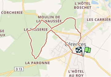
Cérence balade de la chaussée

mousetik
User

Length
4.5 km

Max alt
59 m

Uphill gradient
81 m
Km-Effort
5.6 km

Min alt
23 m

Downhill gradient
82 m
Boucle
Yes
Creation date :
2023-08-08 14:01:51.337
Updated on :
2023-08-08 15:23:16.579
1h21
Difficulty : Easy

FREE GPS app for hiking
 SityTrail
IGN / Geographical institutes
SityTrail Plus
The world is yours!
About
Trail Walking of 4.5 km to be discovered at Normandy, Manche, Cérences. This trail is proposed by mousetik.
Positioning
Country:
France
Region :
Normandy
Department/Province :
Manche
Municipality :
Cérences
Location:
Unknown
Start:(Dec)
Start:(UTM)
614667 ; 5418986 (30U) N.
Comments