


Re iereb steven

odindach
User
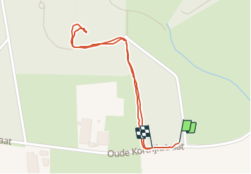

Length
970 m

Max alt
54 m

Uphill gradient
12 m
Km-Effort
1.1 km

Min alt
41 m

Downhill gradient
10 m
Boucle
Yes
Creation date :
2023-08-09 08:16:19.703
Updated on :
2023-08-09 08:36:58.964
20m
Difficulty : Easy

FREE GPS app for hiking
 SityTrail
IGN / Geographical institutes
SityTrail Plus
The world is yours!
About
Trail Walking of 970 m to be discovered at Flanders, West Flanders, Zonnebeke. This trail is proposed by odindach.
Positioning
Country:
Belgium
Region :
Flanders
Department/Province :
West Flanders
Municipality :
Zonnebeke
Location:
Zonnebeke
Start:(Dec)
Start:(UTM)
499779 ; 5632995 (31U) N.
Comments