


lac d'Emosson-col de barberine-finhaut

jeff2
User
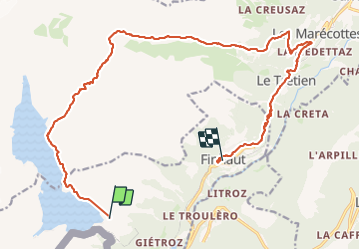

Length
21 km

Max alt
2478 m

Uphill gradient
1091 m
Km-Effort
38 km

Min alt
995 m

Downhill gradient
1842 m
Boucle
No
Creation date :
2023-08-08 07:14:18.533
Updated on :
2023-08-09 11:23:01.255
6h00
Difficulty : Easy

FREE GPS app for hiking
 SityTrail
IGN / Geographical institutes
SityTrail Plus
The world is yours!
About
Trail Walking of 21 km to be discovered at Valais/Wallis, Saint-Maurice, Finhaut. This trail is proposed by jeff2.
Description
Belle balade
Positioning
Country:
Switzerland
Region :
Valais/Wallis
Department/Province :
Saint-Maurice
Municipality :
Finhaut
Location:
Unknown
Start:(Dec)
Start:(UTM)
340481 ; 5103741 (32T) N.
Comments